About:
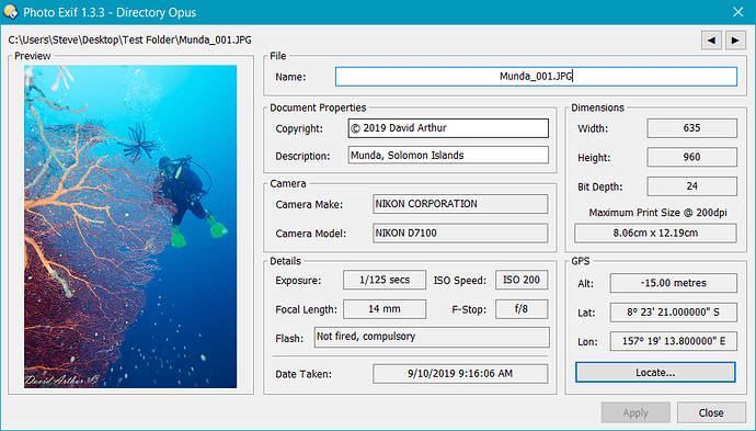
This Script AddIn provides a new Command to Opus (PhotoExif) which presents the Exif information from an image file in a dialog. (Nothing that Opus doesn't already do so it's unlikely to be of use to anyone (including me  ) but I'm stuck at home like most of us and playing around with Opus scripting is keeping me from going loopy).
The initial idea was shamelessly copied from a post by @auden - Displaying Metadata Created by "File Meta" .
The dialog allows you to rename the file and add/change the copyright and description information. Clicking on the image preview shows the image in Opus's viewer. If the image has GPS information then you can click the Locate button to launch your browser (mapping service is configurable) to show the location where the photo was taken.
Installation:
- Download: Photo Exif 1.3.3.js.txt (23.5 KB) Requires at least DOpus 12.20.1 Beta.
- Download: Photo Exif 1.3.js.txt (19.5 KB)
- Drag the .js.txt file to Preferences / Toolbars / Scripts.
History:
-
1.0 (29/3/20)
- Initial Release.
-
1.1 (9/4/20)
- Added 'update' button to update the dialog when users select a different file in the lister.
- Dialog now remembers its position.
- Basic error handling for files that no longer exist.
-
1.2 (10/4/20)
- Now automatically monitors for file selection changes and updates the dialog, no longer requires the 'update' button.
- New config option to toggle the automatic monitoring.
- Numerous bug fixes relating to non-image file selection.
-
1.3 (11/4/20)
- Rotates preview image if rotation data exists. This slows things down a lot so by default it's off but can be toggled on with a new config option : "Rotate Image".
-
1.3.2 (21/4/20)
From this version on the script requires the latest beta of DOpus (12.20.1).- Now uses the DOpus internal image rotation functionality - much faster.
-
1.3.3 (23/4/20)
- Bugfix: File rename had broken somewhere along the line.
- Bugfix: Clicking the preview image would only show the original image shown in the dialog.
- Bugfix: GPS co-ords didn't clear properly when an image had none.
- Added: New Left (◄) and Right (►) buttons which allow you to move file selection in the Lister up or down without having to click in the Lister.
- Added: Option location_service option in config - allows a choice of which mapping service is used when the Locate button is clicked (Google Maps, Open Street Maps and Bing).
- Added: Converts Latitude/Longitude to Degrees, Minutes and Seconds.
- Minor dialog tweaks.
Config:
A number of options are available in the normal Script AddIn configuration editor.
- dpi - Sets the DPI number which is used to calculate the printable size.
- inches - Set this to true to show the printable size in inches rather than centimetres.
- selection_update - If set to true the dialog will monitor for and update the dialog when another image file is selected.
-
image_rotation - Rotates preview image if the image has rotation data (default is off as it slows things down a LOT).
- From v1.3.2 this option no longer significantly slows things down so the default is now on.
- location_service - Choose which mapping service is launched when you click the Locate button (options are Google Maps, Open Street Maps and Bing).
Usage:
- Download: Photo Exif.dcf (240 Bytes)
- Select "Settings/Customize Toolbar..." from your Lister and then drag the button file to any toolbar you like.
- Select an image file in the lister and click the new button (Photo Exif). A new dialog should appear displaying the exif information for that file.
While the dialog is displayed, select another image file and the display should update automatically. You can click the Left (◄) or Right (►) arrow buttons to change the file selection.
Editable fields include the Filename, Copyright and Description fields. If you edit these items, click the Apply button to save the changes.
The Locate button will be available only if there are GPS coordinates in the current selected image file. Click the button to show the location of the image in the configured mapping service.


